Every now and then we encounter things that fascinate us so much that we make maps of them. Either to get an overview, to see spatial facts in perspective or just to show facts in a simplified way. Here you can find an overview of these thematic maps, which are of course always extended.
Russia
Lake Baikal and other capitals
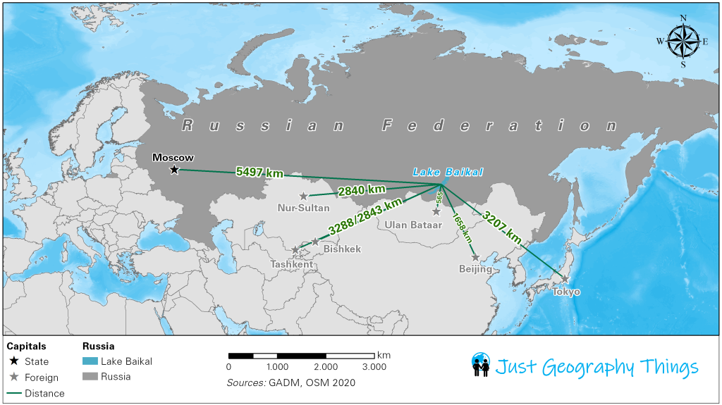
Russia is known to be the largest country in the world in terms of area. With Moscow, the Russian capital is huge, a total of about 12 million inhabitants (of the total 144.5 million inhabitants of Russia) live there. When we were at Lake Baikal, a post with distance information aroused our interest: on said post many cities were listed, sometimes 1,000 km, sometimes 2,000 km and sometimes 3,000 km away. But the own capital was more than 5,000 km away in the west of the country. So we thought, it would be interesting to know which capitals are closer to Lake Baikal than our own. Here is the result – of course we did not consider all capitals, but those of the countries we visited and the next capital to Lake Baikal: Ulan Bataar in Mongolia, just 565 km away.

Central Asia
The Antique Silk Road
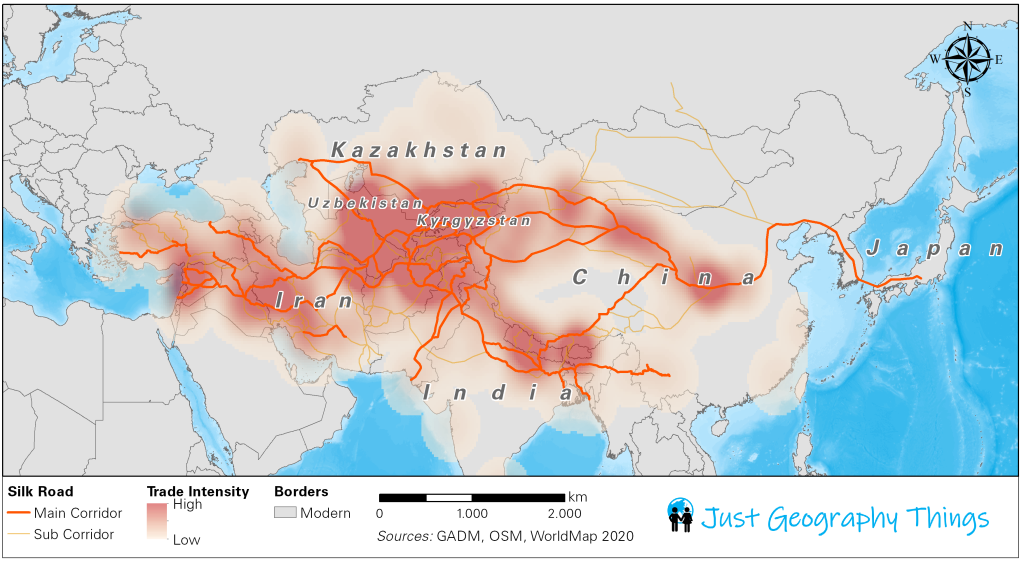
The traders at the bazaars of Almaty, Bishkek, Tashkent, Samarkand or Bukhara are busy at any time of the day. Many people crowd through the narrow corridors of the old buildings, where there was lively trading many centuries ago. Nowadays, the Silk Road has largely shifted to the sea under the name New Silk Road, but the ancient remains of the old trading network are still there. Central Asia in particular was of great importance at that time – a veritable hotspot of caravanserai and trading centres had developed there. As a result, some of the main corridors of the ancient Silk Road passed through today’s Central Asian countries.

Japan
Typhoons are the order of the day
We take the bus from Aomori (the north of Honshu) to the south, more precisely to Ebina near Mount Fuji. Even before we got on the bus, we were warned that a typhoon was about to hit the country, which is said to have extraordinary strength. Nevertheless we are calm, because on GoogleMaps for Japanese typhoons there is a tool that maps the movement of the typhoon and models when the eye of the storm will be at which place. We are moving in the opposite direction to the typhoon and therefore do not have to worry. Nevertheless, our interest is aroused: Japan is known for its devastating hurricanes and so we sit down at the computer and research if we can find a georeferenced file on hurricanes in Japan – we will find it. The map below shows all typhoon tracks from 1970 to 2019. This time we have created a minimalist map, because in this case you don’t need any borders to orientate yourself:

South-East Asia
Volcanos of Indonesia
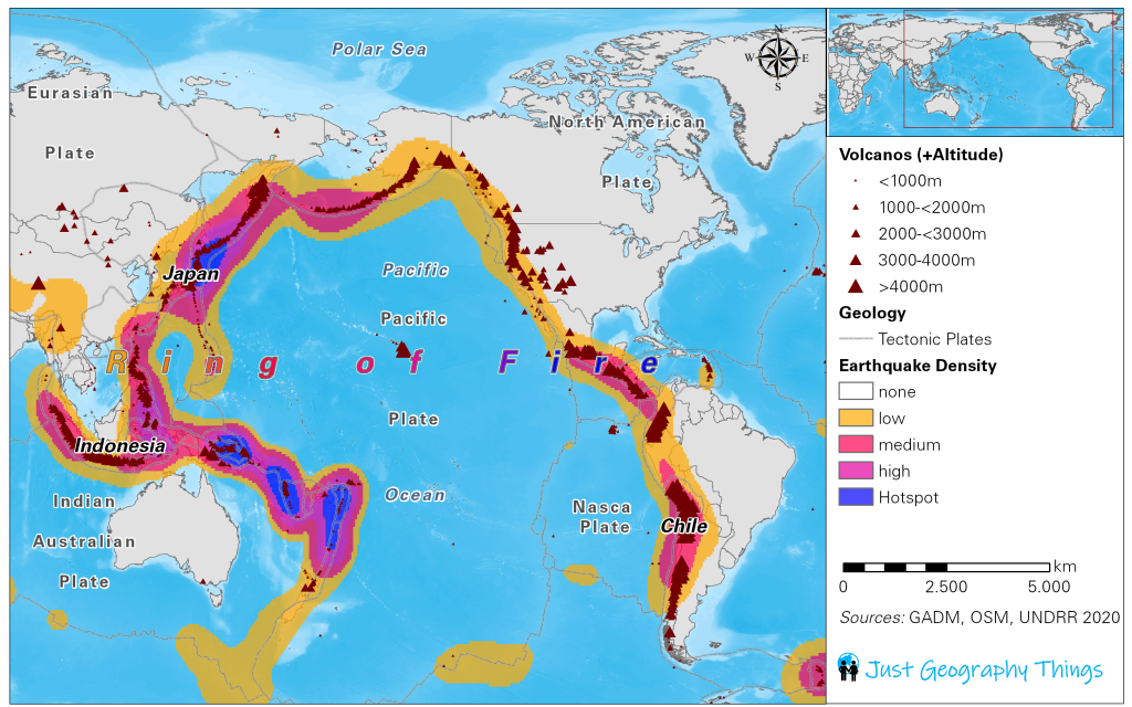
Bereits beim Anflug von Indonesien kann man die Vulkanespitzen der Inseln Bali und Java erkennen. Diese erheben sich majestätisch über das restliche Flachland des Inselstaates und formen häufig wunderschöne Stratovulkane – perfekte Kegel! Indonesien hat eine extrem hohe Zahl an Vulkanen verteilt auf die vielen Insel die den Staat formen. Dabei ist Indonesien ein wichtiger Bestandteil des berühmten Ring of Fire. Dieser spannt sich um den Pazifik und wird Feuerring genannt, da sich hier kreisförmig die bedeutensten Vulkan-Hotspots der Erde befinden, quasi wie ein Feuergürtel. Auf der Westseite (vom Pazifik aus betrachtet) subduziert die Pazifische Platte unter die Eurasische Platte, auf der anderen Seite subduziert die Nasca-Platte unter die Südamerikanische Platte. Somit entstehen die mächtigsten Vulkane unseres Planetens. Doch nicht nur Vulkane entstehen an den Plattengrenzen, sondern auch eine Menge Erdbeben. Da Vulkane und Erdbeben häufig an den selben Orten auftreten, haben wir in einer Karte den Ring of Fire sowie die Erdbebenintensität aufgetragen:

Patagonia
Campo de Hielo Sur
The Campo de Hielo Sur is a huge ice field in southern Patagonia. The ice mass is located at the border between Argentina and Chile – there is even a part of the border which is disputed. Both Argentina and Chile claim the area that is only covered by ice for themselves, which is why many cartographers put a rectangle at this point in order to do justice to the unsolved borderline problem.
The Campo de Hielo Sur is the third largest contiguous ice field on earth after Antarctica and the Greenland Ice Shield.
We were able to see the huge ice field up close on our hike on the Vuelta al Huemul near the small town El Chaltén! As we were so fascinated by the sheer dimensions, we made a map showing the position of the ice field in South America, its topographical position and its size ratio.

The Retreat of Glacier Grey
Glaciers are threatened worldwide by climate change. The huge ice masses are decimated mainly by rising temperatures and the lack of snow. We also noticed this during our hike through the Torres del Paine Parque Nacional in the south of the Chilean part of Patagonia. There there are some glaciers on a small area to look at, the biggest is thereby the glacier Grey. This lies in a valley and extends as a long ice tongue up to the lake of the same name. The lake extends thereby still some kilometers further and this sight triggered the question in us, by how much distance the glacier had already decreased. The global glacier database glims.org, which uses remote sensing data to record the changes in glaciers worldwide, helped us to find the answer. This data was supplemented by historical data from photographs (or similar) and resulted in the following result for Glacier Grey:

Inconsistencies in Maps – Territorial Claims in Antarctica
The largest ice sheet on earth extends as a white desert around the South Pole. No people live here permanently, but there are all the more research stations that deal with climate, climate change but also with the resources that are suspected to be under the Antarctic ice cover. Some countries have made territorial claims on the ice sheet, including Argentina and Chile. When we landed in Punta Arenas, the airport that is considered the gateway to Antarctica, we saw the first large map of Chile, which also represented the territorial claim in Antarctica. We memorized it well – it was also very simple, because it was the Antarctic Peninsula at the Bellinghausen Sea (the characteristic hook that sticks out of the otherwise quite round ice). When we entered Argentina a few weeks later, we were surprised when we saw the first official maps – they make almost the same territorial claim to the Antarctic landmass as Chile does. This problem has not yet escalated, but both Argentina (Islas Malvinas or Falkland Islands) and Chile (Northern Chile, Southern Bolivia, Southern Peru) have proven in the past that territorial conflicts are addressed by force of arms.

